Rajmahal Traps Fm
Type Locality and Naming
The Rajmahal Hills (24°30'N; 87°30'E) of Jharkhand is the type area of this province.
Synonym: Rajmahal Stage.
Lithology and Thickness
Basalt. In the type area, multiple layers of solidified lava made the 608-meter-thick Rajmahal Traps which are dipping 2–5° towards the north-east. Individual layers vary in thickness from less than 1 meter to more than 70 meters. The Rajmahal volcanics are predominantly tholeiitic basalt, quartz tholeiite, olivine tholeiite and alkali basalt. Two of the flows are of pitchstone. The basalts are commonly dark colured, porphyritic with an unusually fine-grained matrix. At the type section, the top-most flow is the thickest one (76m). The Intertrappean Beds are shale and clay beds, some of these being silicified and porcellanoid. Total thickness of the intercalated sedimentary beds is only 30 m, each being 1.5 m to 6.0m thick..
Relationships and Distribution
Lower contact
In West Bengal Basin, it is unconformably overlain by Dhanunjayapur Fm. In NW Bangladesh, it is conformably overlain by the Shibganj Trapwash Fm (a weathering product) or unconformably by the Bolpur Fm.
Upper contact
In Gondwana Basins, it unconformably overlies the Dubrajpur Fm.
Regional extent
The Rajmahal Traps is a volcanic igneous province in Eastern India, covering the parts of Jharkhand, West Bengal and Meghalaya. In Bangladesh, Rajmahal Trap rocks have been encountered in the subsurface in the Bogra, Jamalganj, Shibganj and Singra areas of the western part of Bangladesh, having thickness ranging from 68 to 546m. Singra (24°29'52N; 89°10'50E) has two trap beds with one intertrappean bed.
The original lava flow covered an area of nearly 4,100 km2. Below the surface in the Bengal basin, the flows cover 200,000 km2.
Coeval (approximately) with nearby Bengal Traps Fm , Sylhet Traps Fm (immediately NE of Bangladesh in North East Basins of India), and Salipur Volcanics Fm (Mahanadi Basin).
GeoJSON
Fossils
The Intertrappean Beds contain an assemblage of Lower Cretaceous plant fossils. The assemblage includes Cladophlebis indica, Dictyozamites indicus, Taeniopteris spatulata, and Brachyphyllum rhombium.
Age
Depositional setting
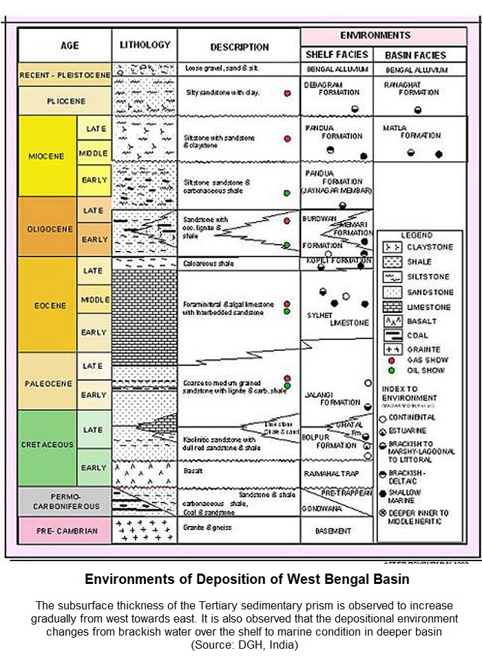
[Figure: Environments of Deposition of West Bengal Basin (from dghindia.gov.in)]
Additional Information
These volcanic rocks were formed from the eruptions over the Kerguelen hotspot in the early Cretaceous, and are at the head of the Ninetyeast Ridge track of that hotspot as India drifted northward. Basalt provinces attributed to the Kerguelen plume include Kerguelen and Naturaliste Plateaus (in the southern Indian Ocean; ca. 118-110 Ma), Bengal Traps (ca. 118 Ma), Broken Ridge (ca. 94-95 Ma), Ninetyeast Ridge (ca. 82 to 38 Ma), Bunbury basalts (southwestern Australia, ca. 130 Ma) and Rajmahal Traps. Drill core data and samples of the Bengal basin lowlands indicate the continuity of the Bengal Traps beneath the Gangetic – Brahmaputra alluvium.
These brief excerpts are mainly copy-pasted from Wikipedia (https://en.wikipedia.org/wiki/Rajmahal_Traps), from Large Igneous Province information (Basu, 2011; http://www.largeigneousprovinces.org/11jun), and Banglapedia (http://en.banglapedia.org/index.php/Geological_Group-Formation; 2015)
